
Is GA Included in NASA’s Low-Altitude Drone Traffic Management Program?
By Scott Spangler on February 9th, 2015 Late last year, NASA launched it Unmanned Aerial System (UAS) Traffic Management (UTM) program to devise and test an automated system that would keep drones from bumping into each other as they performed a variety of missions. What concerns me is that nowhere in the online presentation, or in a Google search of news about the UTM program, did NASA mention anything about the users who’ve been occupying this low-altitude airspace for more than a century—aircraft occupied by humans.
Building on the lessons learned over the life of the air traffic management (ATM) of occupied aircraft, NASA’s solution “would enable safe and efficient low-altitude airspace operations by providing services such as airspace design, corridors, dynamic geo-fencing, severe weather and wind avoidance, congestion management, terrain avoidance, route planning and re-routing, separation management, sequencing and spacing, and contingency management.”
Noting that “UTM is essential to enable the accelerated development of civilian UAS applications,” by 2019 NASA hopes to develop and demonstrate an automated system that also provides data to its human managers. NASA’S website compared the result to the roads, signs and signals, and rules that guide safety vehicles that operate in two dimensions. Think that through for a moment, and consider what it might mean for general aviators.
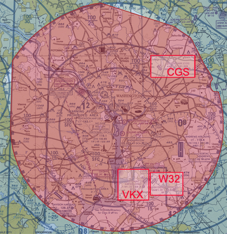 The only tangential hint at human aviation comes with UTM’s use of geo-fencing, the GPS delineation of drone no-fly zones. After one of its drones wandered over to the White House, DJI issued a mandatory firmware update that adds such a zone, centered on Washington, DC, to the list of 10,000 airports.
Surrounding airports with geo-fences will certainly increase safety, but what about in the low altitude airspace between them? Because drones and general aviation aircraft will share this narrow band of atmosphere, will they be required to install the communication, navigation, and surveillance equipment the drones must have for the automated UTM system to work?
And when the two meet, who must give way, airplane or drone? Or will first-person pilots have to follow the UTM signs and signals as they keep to the aerial roads the system creates for them? Some might argue that first-come, first served, but what about the time in the not to distant future when drones vastly outnumber the operation of populated aircraft? – Scott Spangler, Editor
Related Posts:


February 9th, 2015 at 3:35 pm
Another question to consider;
If we’re all going to be jammed onto these “aerial roads”, will this create greater congestion? Which, in turn leads to an increased number of “incidents”?
February 9th, 2015 at 7:08 pm
I fear that UAV’s, with their governmental and commercial interests, will severely restrict and eventually eliminate personal general aviation. Airspace restrictions will favor the UAV’s and at the very least VFR flight will be ended. The government (Homeland Security) already hates the thought of VFR aircraft being able to move around the nations airspace being unknown/uncontrolled and would just love to end VFR right now. Aviation groups and periodicals keep posting these seemingly positive articles on the “up and coming UAV’s” but doesn’t realize they are potentially the biggest threat to GA.
February 9th, 2015 at 7:16 pm
I fly about 3,000 to 4,000 feet in the general area, about 100 or so square miles, and don’t usually have to worry about some idiot not really paying attention to other possible planes in the area. With the reports we’re hearing and seeing around now, these unmanned aerial pieces of equipment and their operating morons have no idea of the problems they’re creating, and what’s worse, they don’t seem to care.